Cove Neck, New York
Cove Neck, New York | |
|---|---|
| Incorporated Village of Cove Neck | |
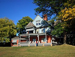
 Sagamore Hill, Cove Neck's best-known landmark, September 2007 | |
 Location in Nassau County and the state of New York. | |
| Coordinates: 40°52′40″N 73°29′50″W / 40.87778°N 73.49722°W | |
| Country | |
| State | |
| County | Nassau |
| Town | Oyster Bay |
| Incorporated | 1927 |
| Government | |
| • Mayor | Thomas R. Zoller |
| Area | |
| • Total | 1.56 sq mi (4.05 km2) |
| • Land | 1.28 sq mi (3.33 km2) |
| • Water | 0.28 sq mi (0.72 km2) |
| Elevation | 23 ft (7 m) |
| Population (2020) | |
| • Total | 293 |
| • Density | 228.19/sq mi (88.10/km2) |
| Time zone | UTC-5 (Eastern (EST)) |
| • Summer (DST) | UTC-4 (EDT) |
| ZIP code | 11771 |
| Area codes | 516, 363 |
| FIPS code | 36-18597 |
| GNIS feature ID | 0947571 |
| Website | www |
Cove Neck is a village located within the Town of Oyster Bay in Nassau County, on the North Shore of Long Island, in New York. The population was 286 at the 2010 census.[2]
History
[edit]Cove Neck incorporated as a village in 1927.[3]
Cove Neck is the site of the home of President Theodore Roosevelt.[4][5] His estate, Sagamore Hill, is now a museum operated by the National Park Service.[4] It attracts many visitors annually.[4]
On January 25, 1990, Avianca Flight 052, which was operated by one of the airline's Boeing 707 jetliners, ran out of fuel before crashing into a hillside in Cove Neck.[5][6][7] 73 out of the 158 passengers and crew on board died in the accident.[7]
Geography
[edit]According to the United States Census Bureau, the village has a total area of 1.6 square miles (4.1 km2), of which 1.3 square miles (3.4 km2) is land and 0.3 square miles (0.78 km2), or 18.47%, is water.[8]
The village is located on a peninsula projecting into Oyster Bay.[9] It is located directly across from Centre Island.[9]
Demographics
[edit]| Census | Pop. | Note | %± |
|---|---|---|---|
| 1930 | 276 | — | |
| 1940 | 130 | −52.9% | |
| 1950 | 200 | 53.8% | |
| 1960 | 299 | 49.5% | |
| 1970 | 344 | 15.1% | |
| 1980 | 331 | −3.8% | |
| 1990 | 332 | 0.3% | |
| 2000 | 300 | −9.6% | |
| 2010 | 286 | −4.7% | |
| 2020 | 293 | 2.4% | |
| U.S. Decennial Census[10] | |||
As of the census[11] of 2000, there were 300 people, 110 households, and 83 families in the village. The population density was 233.4 inhabitants per square mile (90.1/km2). Cove Neck is the least densely populated community in Nassau County. There were 140 housing units at an average density of 108.9 per square mile (42.0/km2). es living together, 7.3% had a female householder with no husband present, and 24.5% were non-families. 19.1% of households were one person and 11.8% were one person aged 65 or older. The average household size was 2.73 and the average family size was 3.16.
The age distribution was 26.3% under the age of 18, 4.7% from 18 to 24, 20.3% from 25 to 44, 29.3% from 45 to 64, and 19.3% 65 or older. The median age was 44 years. For every 100 females, there were 96.1 males. For every 100 females age 18 and over, there were 87.3 males.
Government
[edit]As of December 2021, the Mayor of Cove Neck is Thomas R. Zoller and the Village Trustees are Joseph Castellano, Marjorie Isaksen, and Marta Kelly.[12]
Politics
[edit]In the 2016 U.S. presidential election, the majority of Cove Neck voters voted for Hillary Clinton (D).[13]
Education
[edit]The entirety of Cove Neck is located within the boundaries of (and is thus served by) the Oyster Bay-East Norwich Central School District.[9][14] As such, all children who reside within the village and attend public schools go to Oyster Bay–East Norwich's schools.[9]
Notable people
[edit]- John McEnroe – Tennis player.[5]
- Theodore Roosevelt – 26th President of the United States.[4]
- Charles Wang – Businessman and former owner of the New York Islanders.[5]
References
[edit]- ^ "ArcGIS REST Services Directory". United States Census Bureau. Retrieved September 20, 2022.
- ^ "Race, Hispanic or Latino, Age, and Housing Occupancy: 2010 Census Redistricting Data (Public Law 94-171) Summary File (QT-PL), Cove Neck village, New York". United States Census Bureau. Retrieved October 3, 2011.
- ^ Winsche, Richard (October 1, 1999). The History of Nassau County Community Place-Names. Interlaken, New York: Empire State Books. ISBN 978-1557871541.
- ^ a b c d "Sagamore Hill". www.coveneck.org. Retrieved December 20, 2021.
- ^ a b c d "Long Island History: Cove Neck". August 11, 2005. Archived from the original on August 11, 2005. Retrieved December 20, 2021.
- ^ Ranter, Harro. "CVR transcript Avianca Flight 052 - 25 JAN 1990". Aviation Safety Network. Retrieved December 20, 2021.
- ^ a b Navarro, Mireya (June 25, 1990). "For Some, No Escape From L.I. Jet Crash". The New York Times. ISSN 0362-4331. Retrieved December 20, 2021.
- ^ "US Gazetteer files: 2010, 2000, and 1990". United States Census Bureau. February 12, 2011. Retrieved April 23, 2011.
- ^ a b c d "Long Island Index: Interactive Map". www.longislandindexmaps.org. Retrieved December 20, 2021.
- ^ "Census of Population and Housing". Census.gov. Retrieved June 4, 2015.
- ^ "U.S. Census website". United States Census Bureau. Retrieved January 31, 2008.
- ^ "Village Officials". www.coveneck.org. Retrieved July 24, 2024.
- ^ Welch, Will (November 8, 2017). "How Long Island Voted". Newsday. Retrieved December 20, 2021.
- ^ "Composite School District Boundaries Shapefiles". NCES. Retrieved October 23, 2020.


